
CRONOLOGIA
1638 Bc The eruption of Santorini in created a tsunami with wave height of 50 m.
The tsunami was responsible for the destruction of the population on Crete.
1775 November 1: the great Lisbon earthquake generates a wave up to 6 metres high that strikes coastal Portugal , Spain and Morocco .
1883 August 27: the eruption of the volcano Krakatau generates a massive wave that sweeps over the shores of nearby Java and Sumatra , killing 36,000 people.
1896 June 15: the Sanriku tsunami strikes Japan without warning. A wave estimated at more than 23 metres high hits a crowd gathered to celebrate a religious festival, killing more than 26,000 people.
1896 December 17: a tsunami washes away part of the embankment and main boulevard of Santa Barbara , California .
1906 January 31: a devastating offshore quake submerges part of Tumaco , Colombia , and washes away every house on the coast between Rioverde , Ecuador , and Micay , Colombia . Death toll estimated at 500 to 1,500.
1908
1929
1946 April 1: Alaskan quake generates tsunami that destroys North Cape Lighthouse, killing five. Hours later the wave arrives at Hilo , Hawaii , killing 159 people and doing millions of dollars in damage.
1952
1957
1960
1960 May 22 : a wave reported as up to 11 metres high kills 1,000 in Chile and causes damage in Hawaii , where 61 die, and in the Philippines , Okinawa and Japan as it sweeps across the Pacific.
1960 uno tsunami si abbattè sul Giappone alla velocità di circa 750 chilometri l'ora. Era nato al largo delle coste cilene a causa d'un movimento tellurico che aveva sollevato di circa 9 metri un territorio sottomarino grande quanto la California.
1964
1964 March 28: Good Friday earthquake in Alaska sends out a wave swamping much of the Alaskan coast and destroying three villages. The wave kills 107 people in Alaska , four in Oregon and 11 in California as it sweeps down the West Coast.
1975
1976 August 16 : a tsunami kills more than 5,000 people in the Moro Gulf region of the Philippines .
1992 settembre un'onda anomala distrusse alcuni villaggi del Nicaragua uccidendo 13 mila persone.
Nel dicembre 1992, una serie di onde anomale provocò migliaia di morti in Indonesia.
1996 (June 10) Andreanov
1998 (July 17) Papua New Guinea: an offshore quake triggers a wave that strikes the north coast of Papua New Guinea killing some 2,000 people and leaving thousands more homeless.
1999 (November 26) Vanuatu
2001 (January 13) El Salvador
2001 (June 23) Peru
2002
2003 (September 25) Hokkaido
2004 (26 Dicembre) Indonesia
the most powerful earthquake in 40 years triggers waves that travel thousands of miles to crash onto the coastlines of at least five Asian countries, killing more than 7,000 people and affecting millions of others
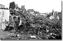
1908 (28 Dicembre) Messina&Reggio
Reggio e Messina furono distrutte da uno Tsunami che uccise 85.000 persone, zona a maggiore rischio idro/geologico di tutta l'Europa.
Era notte fonda alle 5,21 del 28 dicembre del 1908. I sopravvissuti, negli anni successivi, hanno raccontato di un boato terribile, un rumore prolungato, mai ascoltato. In realtà, un'infinita manciata di secondi per uccidere centomila o forse più persone, per cancellare il lavoro e la fatiche immani di 125 anni, tanti quanti ne erano passati, in questa terra «ballerina» tra Messina e Reggio Calabria, dal precedente sisma del 1783, devastante solo un po' meno di quello della più tragica alba dell'Otto. A Messina fu peggio. Sotto le macerie di 96 anni fa meno un giorno, restarono 80mila dei suoi 130mila abitanti. Per giorni e giorni una nuvola oscurò il cielo. Sotto una pioggia torrenziale, al buio, i sopravvissuti, inebetiti dalla tragedia, privi di riferimenti e pudori umani vagarono all'impazzata senza riuscire a rendersi conto di cosa fosse capitato. Molti pensarono alla fine del mondo. Tanti morirono per le esplosioni e gli incendi improvvisi che s'innescarono per la rottura delle tubature del gas. Uno spettacolo apocalittico, identico solo a quello vissuto nella «città sorella» di fronte, a Reggio, dove quasi 20mila dei 45mila abitanti del tempo morirono. Ma il calvario e l'apocalisse non era ancora giunta al culmine. Su entrambe le coste all'improvviso le acque del mare si ritirarono come se un'immensa spugna avesse tolto l'acqua. Pochi minuti soltanto e, senza dare a nessuno il tempo per fuggire, tre ondate gigantesche travolsero quel mare di dolore. Le marine delle due città vennero semplicemente cancellare: il ritirarsi del mare risucchiò cadaveri e feriti, barche e povere case di pescatori. Molti sopravvissuti sostengono che fu proprio la cattiveria del mare, con quelle micidiali ondate alte 10 metri , a fare il grosso dei danni. Tutti i paesini delle coste a nord e sud di Reggio e Messina vennero ingoiati. Mentre tra Messina e Reggio si consumava la tragedia il mondo sapeva di un terremoto violentissimo che si era registrato chissà dove. Le strumentazioni dell'epoca registravano terremoti anche lontanissimi ma le rivelazioni sul luogo non esistevano. Per parecchie ore le capitali d'Europa si interrogarono per capire a chi fosse capitata questa volta la disgrazia. Anche il governo italiano ignorò a lungo il disastro. Il telegrafo, la luce e qualsiasi altro mezzo di comunicazione erano saltati. Quel che era rimasto delle autorità di Messina, diede ordine che tra le navi del porto, in gran parte finite una sull'altra, si aprisse un varco per fare uscire qualcuna delle torpediniere della Regia Marina di stanza in città. Il varco venne aperto dalla «Saffo». Un po' dopo la «Spica», malgrado un mare turbolento e rischioso prese il largo e alcune ore dopo raggiunse, in Calabria, Marina di Nicotera da dove venne trasmesso un dispaccio al governo che venne informato, ovviamente in modo molto approssimativo e con una valutazione ancora insufficiente degli accaduti, alle 17,25, cioè dodici ore e 4 minuti dopo. Ancora un paio d'ore e Giolitti riunì in governo per le prime decisioni. I giornali, il giorno dopo, diedero notizie succinte e approssimative. Solo col passare delle ore e dei giorni il dramma diventò palese in tutta la sua terribile grandiosità e arrivarono informazioni più certe. Il paese, sbalordito, fu informato che a Reggio e Messina interi quartieri erano crollati, che sotto le macerie di case, ospedali e caserme erano scomparsi interi nuclei familiari, malati, funzionari, guardie e soldati. Venne inoltre a conoscenza della gara di solidarietà apertasi tra navi straniere ed italiane per portare aiuto ai superstiti e trasportare sui luoghi colpiti dal sisma i materiali e gli uomini necessari. Successivamente il paese scoprì anche che tutti i vincoli che erano stati stabiliti all'indomani e in seguito al terremoto del 1783 col passare del tempo erano stati ignorati, causa non ultima della dimensione del dramma che aveva spazzato come fuscelli case e palazzi tirati su risparmiando e speculando sui costi. Sopravvissuti, volontari e soldati italiani e stranieri dopo il panico e lo sbandamento iniziale iniziarono a scavare. Vennero tirate fuori dalle macerie e salvate 17.000 persone. 13.000 le salvarono i militari italiani, 1.300 i russi (furono i primi ad arrivare la mattina del 29 a Messina), 1.100 dagli inglesi, 900 dai tedeschi. La paura di quei momenti venne rivissuta per altri 15 mesi quanto durò lo sciame sismico con scosse spesso di intensità notevole e capaci di rinnovare il terrore di quella notte. Per quanto possa sembrare incredibile la tragedia dei terremoti, con l'allontanarsi dal tempo dall'evento, dopo il sangue, la morte di massa e l'eclissi della pietà, s'ingigantisce. Impossibile fare il conto dei morti «successivi» a ogni terremoto, dei vecchi che muoiono prima, dei bambini a rischio, delle vittime di freddo, stenti, privazioni che quasi sempre durano quasi tutta l'esistenza per le vittime; o calcolare i costi che dentro le baraccopoli hanno dovuto pagare, per esempio, generazioni intere di messinesi e reggini.
Infatti la faglia Afro/Europea passa proprio sotto lo Stretto di Messina e causa ciclicamente terremoti violenti e distruttivi come quello del 1908 o come quello, probabilmente ancor più distruttivo ( ci sono pochissime testimonianza) del XVII sec. In questa zona, inoltre, molti vulcani attivi causano di frequente lievi moti sussultori, vedi l'Etna, Vulcano e Stromboli.
On November 18, 1929, at 017:02 Newfoundland time, an earthquake occurred of the coast of Grand Banks , Newfoundland . A tsunami was triggered by a sub-marine landslide and the earthquake, which had a Richter magnitude of 7.2 with an epicenter of 44.5°N, 56.3°W. The tsunami caused $400,000 in damage and killed 29 people, the highest death toll attributed to an earthquake in Canada . The most damaging factor in this event was the sub-marine landslide. The landslide added to the size of the tsunami and damaged many kilometers of 12 transatlantic telegraph cables. The majority of the monetary damage was due to repair costs of the damaged transatlantic cables. Unaware of the danger coming from the sea, the communities of Burin Peninsula , Newfoundland , suffered heavy damages and loss of 29 people. The tsunami was registered as far as South Carolina and Portugal. In 1952 American scientists from Columbia University put together the pieces of the sequentially broken cables that led to discovery of the landslide and the first documentation of a turbidity current. Scientists are looking at layers of sand believed to be deposited by other tsunamis in an effort to determine the occurrence rates of large earthquakes. One sand layer, thought to be deposited by the 1929 tsunami, at Taylor 's Bay was found 13 cm below the turf line. The occurrences of large tsunamis, such as the one in 1929, are dependent upon deposition of sediments offshore because it was the landslide, which made the tsunami so powerful. The deposition of such a large volume of sediments will take awhile before there is enough to for an underwater landslide of size as in 1929.
1952 Kamchatka Peninsula Tsunami
On November 4, 1952, at 16:52 GMT, an earthquake occurred off the coast of the Kamchatka Peninsula, Russia. A Pacific-wide tsunami was triggered by the earthquake, which had a surface-wave magnitude of 8.2, an epicenter of 52.8° N, 159.5° E, and a focal depth of 30 km . Six cows died and no human lives were lost in Hawaii where damage estimates ranged from $800,000- $1,000,000 (1952 dollars).
Flooded street resulting from the arrival of the Kamchatka tsunami on Midway Island about 3,000 km away from the origin. Photograph Credit: U.S. Navy. Source: National Geophysical Data Center. The tsunami had caused severe damage to Kamchatka Peninsula and then proceeded throughout the pacific. Midway Island was innundated with 1 m of water, flooding streets and buildings. On the Hawaiian Islands the waves destroyed boats, knocked down telephone lines, destroyed piers, scoured beaches, and flooded lawns. In Honolulu Harbor a cement barge was thrown into a freighter. In Hilo Bay a small bridge connecting Cocoanut Island to the shore was destroyed by a wave when it lifted off its foundation and then smashed down.
Aerial view of Kaika Bay near Haleiwa on the north shore of Oahu shows the fourth wave climbing up beach toward the beach houses and shows the extent of inundation from previous waves. Photograph Credit: George Curtis. Source: National Geophysical Data Center.
At Cocoanut Island the water swept in with a run-up of 12 feet . It was observed in Hilo that the run-up could have been as high as 11 1/2 feet. Also in Hilo , at Reed's Bay, the water level rose as high as 11 feet . Hilo Bay recorded the highest levels of run-up. At most of the other coastal cities in Hawaii , the water rise was barely noticeable. During this event, the interesting observation was made that the highest or most destructive wave would vary from location to location. Without knowing which wave will be the largest at a particular location the local authorities must properly warn residents that could be affected and keep them away from the shore until it is safe to return.
On March 9, 1957, at 14:22 GMT, an earthquake occurred south of the Andreanof Islands , in the Aleutian Islands of Alaska. A Pacific-wide tsunami was triggered by the earthquake, which had a surface-wave magnitude of 8.3, an epicenter of 51.5° N, 175.7° W, and a focal depth of 33 km . Even though no lives were lost, the Hawaiian Islands suffered the greatest with damage costs approximately $5 million (1957 dollars).
![[Link to Image]](cronologia_clip_image001_0000.jpg)
First photo in a series of three sequential photos show the arrival of a major wave at Laie Point on the Island of Oahu, Hawaii about 3,600 km from the source. Photograph Credit: Henry Helbush. Source: National Geophysical Data Center.
The Island of Kauai, Hawaii, was hit twice as hard by this tsunami than by the Aleutian Islands tsunami in 1946. Houses were washed out and destroyed at Wainiha and Kalihiwai. At Haena, the waves reached heights of 16 m . In addition to that bridges were destroyed and sections of highways were flooded. At Hilo , Hawaii , the run-up was reached 3.9 m and damaged buildings. In Hilo Bay , Cocoanut Island was covered by 1 m of water and the bridge connecting it to shore was destroyed.
![[Link to Image]](cronologia_clip_image003_0000.jpg)
Second photo in a series of three sequential photos show the arrival of a major wave at Laie Point on the Island of Oahu, Hawaii. Photograph Credit: Henry Helbush. Source: National Geophysical Data Center.
Although the northwest side of the Hawaiian Islands received high levels of water, the rest of the islands only received elevated water levels on average of 2 to 3 m . Both the 1946 and 1957 tsunamis occurred in the same general location (the Aleutian Islands ). Even though the 1957 earthquake released more energy than the earthquake of 1946. The tsunami generated by this 1957 event caused less damage than the tsunami of 1946. This uncertainty of the potential destructive power of a tsunami forces Pacific Tsunami Warning System to issue warnings even when a tsunami may have little or no effect.
![[Link to Image]](cronologia_64800111.jpg)
Third photo in a series of three sequential photos show the arrival of a major wave at Laie Point on the Island of Oahu, Hawaii. Photograph Credit: Henry Helbush. Source: National Geophysical Data Center.
On May 22, 1960, at 19:11 GMT, an earthquake occurred off the coast of South Central Chile . A Pacific-wide tsunami was triggered by the earthquake, which had a surface-wave magnitude of 8.6, an epicenter of 39.5° S, 74.5° W, and a focal depth of 33 km . The number of fatalities associated with both the tsunami and the earthquake has been estimated to be between 490 to 2,290. Damage cost estimates were over a half billion dollars.
![[Link to Image]](cronologia_clip_image001_0001.jpg)
Aerial view of coastal area on Isla Chiloe, Chile , showing tsunami damage and wave extent. Two hundred deaths were reported here from the tsunami generated just off Chile 's coast by the magnitude 8.6 earthquake. The inhabitants, fearing the earthquake, took to small boats to escape the shaking. The trough of the tsunami arrived just 10 to 15 minutes after the earthquake, along more than 500 m of the coast. Upon the return of the sea in a thunderous breaker, all boats were lost. The most serious effects occurred in an area extending from Concepcion on the Chilean coast to the south end of Isla Chiloe. Photograph Credit: Unknown. Source: National Geophysical Data Center.
After the tsunami had passed the Hawaiian Islands damage costs were estimated at $24 million and 61 people had died. Hilo , on the main island of Hawaii , was the hardest hit city in the islands. The tsunami arrived at Hilo 14.8 hrs after the it originated off the coast of South Central Chile . The - at Hilo was measured at 10.7m.
![[Link to Image]](cronologia_clip_image003_0001.jpg)
Aftermath of the Chilean tsunami in the Waiakea area of Hilo , Hawaii , 10,000 km from the generation area. Parking meters were bent by the force of the debris-filled waves. Note the scattered debris and the gutted foundation. In the area of maximum destruction, only buildings of reinforced concrete or structural steel, and a few others sheltered by these buildings, remained standing--and even these were generally gutted. Frame buildings either were crushed or floated to the limits of flooding. Photograph Credit: U.S. Navy. Source: National Geophysical Data Center.
![[Link to Image]](cronologia_clip_image005.jpg)
Downtown Hilo , Hawaii , was left devastated by the tsunami. Photo Credit: The Honolulu Advertiser.
Along the Peru-Chile coast the estimated lost of life from the tsunami ranged from 330 to 2000 people and the - was measured as high as 25m. A city along the western coast of the United States which received notable run-up was Crescent City , California , where the run-up reached 1.7 m and the first wave arrived 15.5 hrs after the tsunami was triggered.
![[Link to Image]](cronologia_clip_image006.jpg)
Parking meters along the Hilo bayfront were bent from the tremendous force of the waves. Photo Credit: U.S. Army Corps of Engineers.
1964
Prince William Sound Tsunami
On March 28, 1964, at 03:28 GMT, an earthquake occurred in Prince William Sound of Alaska triggering a Pacific-wide tsunami. The earthquake had a surface-wave magnitude of 8.4, an epicenter of 61.1° N, 147.5° W, and a depth of 23 km . The earthquake, local tsunamis due to landslides, and the regional tsunami were responsible for taking the lives of more than 122 people and causing over $106 million in damage.
![[Link to Image]](cronologia_clip_image001_0002.jpg)
The Surge wave left a 2 x 12 in . (5.2 x 31 cm ) plank in a truck tire at Whittier , Alaska . Whittier incurred $10 million in property damage. One of the waves, probably the same one that caused the major damage in Whittier , reached a height of 31.7 m above low tide. At Whittier the waves destroyed two saw mills; the Union Oil Company tank farm, wharf and buildings; the Alaska Railroad depot; numerous frame dwellings; and the railroad ramp handling towers at the army pier. They also caused great damage to the small boat harbor. The tsunami killed thirteen people at Whittier, then a community of 70 people. Photograph Credit: U.S. Geological Survey. Source: National Geophysical Data Center.
The greatest amount of damage suffered by any location was Alaska . In Alaska the death toll was 106 and there was $84 million in damage. Among Alaskan areas the run-up measurements varied from 24.2 m at Blackstone Bay , 27.4 m at Chenega, 9.1 m at Valdez , and 6.1 m at Kodiak. Outside Alaska it took 5.4 hrs for the first wave to arrive at Hilo , Hawaii , where the run-up was measured at 3.0 m . Another city outside Alaska that received measurable run-up was Crescent City , CA , where a 4.3 m run-up was recorded 4.1 hrs after the tsunami was triggered.
![[Link to Image]](cronologia_clip_image003_0002.jpg)
Both the railroad yard and seaport facilities at Seward , Alaska , received heavy damage.
Even though the regional tsunami was very destructive the local tsunamis also caused significant damage. The local tsunamis were generated by landslides, which were triggered by the earthquake. At the Valdez Inlet a large landslide was triggered by the earthquake generated a tsunami that had a run-up measured at 67.0 m in the inlet. In areas where local tsunamis were generated by landslides nearby cities were given no warning of the oncoming waves. The inability to properly warn the Alaska region prompted the creation of the Alaska Tsunami Warning Center . The warning center can quickly warn towns of any threat of local tsunamis.
On November 29, 1975, at 14:48 GMT, an earthquake occurred off the coast of the Island of Hawaii . A locally felt tsunami was triggered by the earthquake, which had a surface-wave magnitude of 7.2, an epicenter of 19.3° N, 155.0° W, and a focal depth of 8 km . The greatest lost was at Halape, a beach park at the base of a large cliff, on the Island of Hawaii. At Halape, of the 32 campers 19 suffered injuries and 2 died. It was the sounds of the falling rocks from the cliff and the trembling that caused the campers to awake and a few moved to a coconut grove that was closer to the ocean. The campers were awaken by a second quake that sent large boulders down the cliff and forced the rest of the campers to flee toward the sea. However, these campers were forced back to cliffs when the campers at the coconut grove fleeing the rising ocean with cries of tsunami. The first wave that alarmed the campers was only 1.5 m . The second wave, however, was 7.9 m carried campers into a ditch near the base of cliff where they remained until the ordeal ended. Two of the campers were not so lucky and died. The coconut grove that a few campers took shelter in received permanent subsidence between 3.0 and 3.5 meters .The largest recorded run-up was 14.3 m at Keauhou Landing , Hawaii Island . Also on the Island of Hawaii in the small bay of Punaluu the run-up reached 7.6 m . At Punaluu houses were swept off their foundations and properties were damaged. By the time local authorities could sound the coastal sirens the first wave had already arrived. As in the 1964 in Alaska the best warning to the possible danger of a local tsunami is the trembling from the earthquake that triggers it.
http://www.geophys.washington.edu/tsunami/general/historic/historic.html
http://www.pmel.noaa.gov/tsunami/database_devel.html
L'eruzione del vulcano provocò una frana sul costone orientale di Stromboli, riversando tonnellate di massa di roccia lavica finita in mare, nel giro di meno di un'ora tutte le isole Eolie furono bersagliate da onde anomale alte fino a 7- 8 metri con feriti e danni su tutte le zone colpite, fino in Calabria, nella zona di Pizzo Calabro, Tropea, Nicotera dove per fortuna le spiagge erano deserte vista la stagione. Per fortuna quel giorno l'allerta della protezione civile arrivò puntuale, nonostante il poco tempo a disposizione, questo può farci riflettere su quanto sia efficace il servizio di protezione civile in Italia, probabilmente anche a causa delle numerose tragedia subite dalla nostra popolazione, nel tempo, a causa di calamità naturali, terremoti, maremoti, alluvioni, valanghe e via dicendo. anomala che il 30 dicembre 2002 investi' Stromboli era uno tsunami provocato dalla massa di roccia lavica finita in mare a causa della superattivita' del vulcano. Lo ricorda il geofisico Maurizio Ripepe che spiega: ''Il pericolo c'e' sempre ma, a differenza del 2002, oggi lo Stromboli e' uno dei vulcani piu' controllati ed e' stato creato un centro dalla protezione civile sull'isola in grado di dare l'allarme in caso di emergenza tsunami. Certo i tempi di intervento devono essere rapidissimi: l'impatto dello tsunami sulle coste potrebbe avvenire nell'arco di 30 minuti''. Il professor Ripepe, docente del dipartimento di scienze della terra dell'Universita' di Firenze, e' considerato fra i massimi esperti dello Stromboli, al quale ha dedicato fino ad oggi 15 anni di studi. Il suo laboratorio di geofisica sperimentale partecipa, insieme all'Istituto nazionale di geofisica e vulcanologia, al monitoraggio costante del vulcano, per fornire in tempo reale informazioni sull'attivita' del vulcano e sui fenomeni franosi ad esso collegati. Terminale dei dati e' il Coa, il Centro operativo avanzato, appositamente creato sull'isola dalla protezione civile con scopi di allertamento rapido, nel caso di eventuali emergenze. Nel Centro, ricorda Ripepe, e' attivo un sistema ''in grado di dare l'allarme immediato via sms, fax ed e-mail alle autorita' competenti''. ''Sull'isola, come dipartimento di scienza della terra di Firenze - spiega Ripepe -, c'eravamo gia' prima del 30 dicembre 2002. Lo Stromboli e' il vulcano-tipo dell'attivita' esplosiva perche' e' sempre in fase esplosiva. Per noi italiani averlo in 'casa' e' per cosi' dire una fortuna come studiosi. Avevamo per questo gia' un laboratorio, in un edificio dismesso della marina dove siamo ancora: i nostri mezzi erano pero' per cosi' dire limitati, a differenza di oggi''. ''Tutto e' cambiato dopo il 30 dicembre 2002 - prosegue Ripepe -. L'onda anomala di due anni fa ha cambiato le cose: il fenomeno non e' passato inosservato fra gli esperti e soprattutto alla protezione civile. Sull'attivita' esplosiva del vulcano ci sono sempre stati controlli. Non sull'eventualita' di uno tsunami provocato dal distacco di masse di roccia dalla Sciara del fuoco. Certo, in caso di emergenza, occorre che la macchina degli interventi funzioni alla perfezione. Se si formasse un'onda anomala, non occorrerebbero ore per l'impatto sulle coste. In questo caso si parla al massimo di 30 minuti. E l'onda anomala potrebbe arrivare ad interessare le coste fino a Palermo, oltre alla Calabria''. Secondo il geofisico, si deve anche tenere presente che la massa di roccia lavica finita in mare nel 2002, calcolata in 20 milioni di metri cubi, crollo' non in una sola volta, ma almeno in due tempi. Una quantitativo non eccezionale, secondo Ripepe, paragonandolo alla frana del Vajont, ''quando vennero giu' 250 milioni di metri cubi. Se allora a Stromboli si verificasse una frana piu' consistente le conseguenze sarebbe molto maggiori di quello che accade nel 2002''. Rincuora che oggi lo Stromboli non sia in superattivita' come nel 2002 quando, ricorda Ripepe, si registravano esplosioni ogni 2-3 minuti. Ma sopratutto, conclude il vulcanologo, ''prima eravamo disarmati, oggi abbiamo mezzi all'avanguardia per essere in grado di intervenire in caso di tsunami''.
VARI RECENTI